
“We are contributing to Israel’s security and the safety of our soldiers,” says David Harel, CEO of Asio Technologies, a leader in tactical, augmented reality, targeting, orientation and situation awareness solutions, pioneering autonomous and immune optical navigation systems.
“Asio Technologies was founded by ground fighters and field commanders from special units with a technical bent, aiming to leverage their operational experience,” says Harel. These army veterans, he explains, provide cutting-edge systems for the defense market in Israel and around the world.
The company’s systems incorporate electro-optics, hardware and software, providing a complete package for its clients, which include the IDF, foreign armed forces, defense integrators and contractors, and drone manufacturers, among others.
Today, Asio Technologies focuses its activities in two primary areas — systems for soldiers on the battlefield, including tactical battle management systems (BMS), orientation, navigation and observation systems and NavGuard, a mission-critical, GNSS-free optical navigation system for UAS (Unmanned Aerial System) navigation.
Some of the company’s leading battlefield products are the Pointer, a target acquisition system that utilizes proprietary GIS (geographic information system) technology; the Lynx family, a hand-held thermal imager designed for individual soldiers, incorporating augmented reality capabilities; the Orion, a lightweight solution for tactical BMS, mission planning, augmented orientation and enhanced awareness, and the Polaris, a high-accuracy GNSS navigation systems for a wide variety of platforms based on GNSS determination and MEMS (micro-electromechanical system) inclination sensors.
Asio Technologies’ NavGuard is a groundbreaking system used with unmanned aerial systems (UAS), enabling accurate GNSS-free navigation for UAS platforms, where size, power and weight are critical. Most navigating today is based on satellite systems that provide positioning, navigation and timing services on a global or regional basis. The NavGuard System is used in locations where the GNSS signal is disguised, jammed or unavailable.
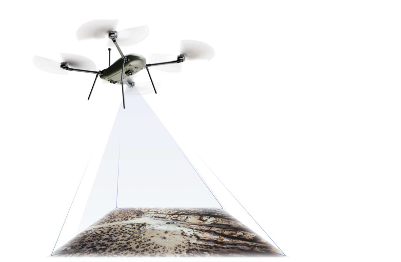
CEO Harel explains that the system is based on machine vision which incorporates optical reference technology, processing video feeds from onboard cameras and converting the information into precise coordinates. He adds that both sides in the current Russia-Ukraine conflict have made extensive use of drones and UAS, both for attacking and for gathering information. “We have seen the tremendous effort put in by both sides to confuse and spoof the other side’s navigation capabilities” By virtue of its ability to navigate without the use of satellite-based systems, the NavGuard System makes jamming of UAS’s GNSS systems irrelevant.
The NavGuard System works in both day and night conditions. It is housed in a completely self-contained housing, incorporating both computing module, database and cameras in a single, compact product. This architecture makes the system resistant to external interference. The NavGuard system provides the same coordinate information that a standard GNSS system offers but without the need to rely on outside data sources or communication.
Harel explains that the uses of systems like NavGuard extend beyond the military to the civilian area and is well-suited in such areas as homeland security and the use of civilian drones for deliveries. “Aviation authorities, such as the Civil Aviation Authority in Israel, require redundancy for critical systems, such as navigation. NavGuard provides this backup,” says Harel.
The system is particularly appropriate for drone delivery services, says Harel, because it is small, lightweight and has low power consumption. Therefore, the weight won’t affect cargo-hauling capacity for delivery-oriented applications, and the power consumption won’t substantially tax flight time or maximum power output. Drones used for shipping in urban areas, he says, are required to have accurate and redundant navigational capabilities, and the NavGuard system provides exactly that. Harel adds that the military market for the NavGuard system is currently the most dominant, but the civil market is rapidly catching up due to the increased growth of drone applications.
Drone manufacturers are purchasing the NavGuard System to integrate into their platforms, and Harel says that in the coming years, it will become an integral part of any UAS around the globe which requires safe autonomous BVLOS (Beyond Visual Line of Site) capabilities.
Asio Technologies develops and designs the hardware and software that is integrated into its devices. The products are assembled in Israel at the company’s site in Rosh Ha’ayin. Harel says that while there are competitors in the market, no one else offers the combination of products and platforms that Asio offers, citing the NavGuard System as an example of being ahead of the curve. “Four years ago, we saw the need for this product, and today we have a mature product and satisfied customers.”
Harel says that the pandemic, which caused millions to remain in their homes, added momentum to the acceptance and usage of drones as delivery devices. Correspondingly, he adds, the increased use of drones has created more regulations for safer navigation. In the coming years, Harel adds, Asio Systems will continue its refinement and development of its systems – particularly the NavGuard – to ensure that it is utilized on as many platforms as possible. “We are going in the right direction,” he says. With the NavGuard System as part of its portfolio, there is little doubt that Asio Technologies will continue on the correct course.
This article is taken from The Jerusalem Post Israel Technology and Innovation Magazine 2022. To read the entire magazine, click here.
This article was written in cooperation with Asio Technologies