
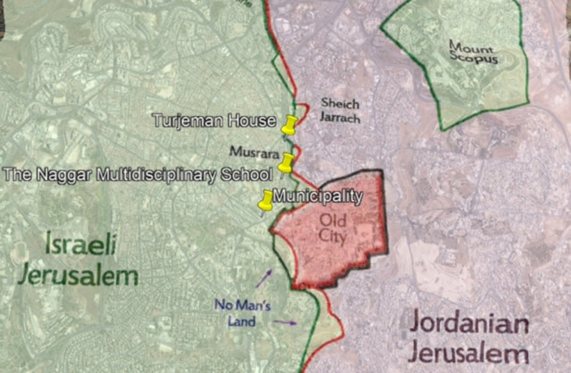
A recent virtual tour, thoughtfully presented by the Jerusalem Foundation, focused on Musrara, a neighborhood crucially located around Safra Square, Jerusalem’s City Hall plaza. The tour, entitled “Exploring Jerusalem’s Seam Lines,” examined one of the most complicated areas in Jerusalem.
Once severed by the 1948 Armistice border, (the so-called Green Line), it is now the hub of the “new city,” (meaning all development outside the Old City). Tour guide Itay Gat, using an interactive map, highlighted three landmark buildings, and the part each played in the historic context from the British Mandate period to the present. The demarcations of the historic happenings can be comprehended in sections: before the War of Independence, between it and the Six Day War; after the Six Day War; and the present.
In terms of population and area, Jerusalem has become the largest city in Israel, although movement outside the walls did not begin until mid-19th century, when wealthy Christian Arabs moved north to escape the crowded Old City, building themselves decorative stone mansions with magnificent entrances, arched terraces, and tall windows. Thus was Musrara founded, a gracious neighborhood indeed.
In 1930, the Christian Arab architect Andoni Baramki designed and built a beautiful and unique home for himself, on a choice plot of land at the edge of the district, purchased from Hassan Bey Turjeman, a local landowner. The upper windows allowed him a view of the Old City and beyond.
During the War of Independence in 1948, Musrara fell to the Israel side. The Turjeman House became an IDF position, adjacent to the Mandelbaum Gate, the only passage between the two parts of the city. The elegant windows of the design became slits, as befitting a military outpost, with the enemy a stone’s throw away. (Just across the road was Steiner House, occupied by Jordan’s Arab Legion.) Residents, of course, were emptying the neighborhood, either entreated to do so by their leaders prior to the battle, or of their own accord due to its proximity. When the battle ceased, and on May 14, 1948 the State of Israel was declared, the neighborhood, including the military outpost, was abandoned, and went on to decline due to neglect, split by the roughly drawn border between Israel and Jordan.
The Green Line is not a straight line. The area is just a couple of kilometers long, an uphill walk to the Temple Mount, an aliyah of sorts. Gen. Moshe Dayan of Israel and Abdullah Tal of Jordan, squatting together midst the destruction, determined on scaps of paper with grease pencils the cease fire line. In diplomatic circles and elsewhere the Green Line is often referred to as the 1967 Armistice Line, or border, but that is a misnomer. The armistice line was drawn in 1948 at the end of the Israeli War of Independence, which gave the Jews their country after two millennia of exile. In 1967, when the Jews captured the Jordanian-held West Bank, reuniting the city, the line ceased to exist. There is no ’67 border. Not in Jerusalem and not anywhere else in the country.
Once the Arab peoples lost the war, the Jews who had lived in Arabia, Morocco, and Egypt, since the destruction of the Temple, and even from the Babylonian conquest, found that their lives, never easy, became beyond unbearable. During the 1950s hundreds of thousands of Jewish refugees were expelled or escaped from these countries, and made their hazardous way, many on foot, to the nascent state. Unlike the UNRWA method, keeping Arab refugees in limbo for several generations where they multiply exponentially, the new State of Israel, budget stretched, struggled from the beginning and throughout the 1950s to settle these refugees, as each new wave was arriving.
The Ministry of Housing put a majority of them in the abandoned Musrara mansions. Majestic as they had been, they had fallen into neglect. Now, they were overcrowded, the children playing in what was a no-man’s land. Remember, in 1948 it was split by the roughly drawn border between Israel and Jordan, a border marked by curls of barbed wire, peppered by landmines. Daily attacks could be expected from snipers on the walls of the Old City. Housing and schools were inadequate, and this was where these kids grew up.
The second building shown was the Mandate’s municipality building designed in the style of the time, with perhaps a little Bauhaus, by British architect Clifford Holliday, financed by Barclays Bank, whose offices occupied the curved front section facing the Old City walls. In those days, nothing would have obstructed the view. A beautiful building, Gat shows it again later, battle scarred with pockmarks from the War of Independence. When Jerusalem was united it became the City Hall (mayor Teddy Kollek insisted on that). In 1972, beautiful stained-glass windows, designed by Israeli artist Avigdor Arikha, were installed in the City Council Chamber. The needs of the city outgrew the facility; today it forms the eastern end of the Safra Square compound.
In the early 1970s there was great excitement due to the immigration of the Jews from Russia. The country, becoming more financially stable, welcomed these Ashkenazi landsmen with generous perks. Second-generation Jewish immigrants from the Mizrachi and Sephardi backgrounds, trying to grow up in spite of poverty and poor schooling, rebelled. Some began to acquire juvenile offender, even criminal, records. In order to bring attention to their discontent, they borrowed the name “Black Panthers” from the African-American protest group in the United States. They were youngsters, really, of 18 or 20, but they learned to effectively use the media to focus attention on their grievances, joined by other neglected communities in the country. The government finally realized they were discriminating unfairly against this segment of the population, and took real steps to address their problems. It wasn’t easy. Prime Minister Golda Meir said they were “not nice.” (A lane in the neighborhood bears a sign “Not Nice Alley”). It took Menachem Begin to address these citizens’ grievances and work effectively to improve the situation. Several individuals went into politics.
The Naggar School of Photography has an interesting story, and the building it is presently housed in is the third in the tour. The school was founded in the 1980s by Avi Sabag, who himself had arrived just three years earlier from Morocco. He sensed the distress among the Jewish immigrants. Loving photography himself, he believed he could encourage youth in the community to widen their horizons through the medium of pictures. He was mistrusted through the first few years, but he persevered. What has evolved verges on the miraculous! The neighbors began to interact with each other, sharing stories, yes, and pictures. Homes opened up to mini exhibits. Other varieties of therapeutic art forms presented themselves, and innovations were welcomed. Of course, Avi’s little shop had to move to larger facilities, and that is our third building, an orthodox synagogue built in the 1930s, at No. 9 Ayin Het Street. It, too, is beginning to bulge at the seams and renovations, including enlargements, are in the works.
As with all tours, virtual or actual, there is always more to learn than one can take in. So it is with this one. Presently, the Turjeman House, having evolved through becoming a military museum, then housing a permanent social conscience exhibit, has become, since 2005, a sociopolitical contemporary art museum dedicated to dialogue and mutual understanding, whose website states that “art is a language without barriers.”
Exhibiting works from artists all over the world, named Museum on the Seam, a glimpse on YouTube convinces one it is not a museum for sissies. The Barclays Bank aka City Hall, our second building, is incorporated into Safra Square, what more can one say? And the Naggar School? The best is yet to come – when we will once again be able to take in their international art festival, held every year in normal times.
Itay Gat, our guide, is to be commended for putting together a most interesting presentation. He is a successful businessman who gave in to his love for Jerusalem and his urge to share it with the world. As mentioned, the tour was presented by the Jerusalem Foundation. International President Shai Doron did the introduction. Since the tour was viewed in May, he was hoping he could announce a cease fire at the event, but that hadn’t happened yet. Present also, virtually, was Nomi Yeshua, the Foundation’s Chief Development Officer. Jerusalem Foundation is the brainchild of Teddy Kollek, who had just become mayor when Jerusalem was reunited. He immediately strove to enhance the cultural and recreational opportunities of the city’s new Arab population. As civic budgets of the day did not allow for enhancements to basic education, he founded the Foundation. One of his legacies is that it is going strong to this day.
The presentation was particularly geared to a Canadian audience, a portion at the end showing the Inukshuk that stands at the entrance to Canada House, (which among other features has an interesting exhibit displaying the history of the Israeli Black Panthers.) Nestled behind Safra Square, this recently renovated community center is a Jerusalem Foundation project, as is the Museum in Turjeman House, and the Naggar School of Photography. City Hall is... well... it’s City Hall.■