")
If you have recently felt that you are trapped between excavations and fenced compounds and are afraid every time you go into the street of falling into a pit or stumbling over scattered construction materials, then there is no room for doubt – you are in Jerusalem.
From the entrance to the city from Sakharov Gardens to the Old City, to the Kalandiya checkpoint in the city’s north, through almost every neighborhood, the city that for thousands of years has looked into eternity is undergoing a physical upheaval, some of which will change its face forever.
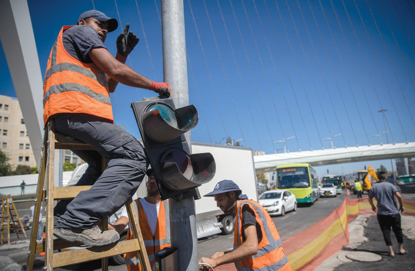
Mayor Moshe Lion, who assumed office over four and a half years ago, made two promises: a cleaning revolution and a transportation revolution in the city. So, less than a year before the next elections for mayor and city council, Jerusalem is clean, including the Old City. But it is full of excavations, fences, construction debris and, above all, traffic disruptions that turn the lives of residents and visitors into a traffic nightmare, as travelers spend endless time in traffic jams.
But in Lion’s vision, all of this is destined to soon disappear and make way for a clean city, full of new apartments in modern high-rises, all connected by a multifaceted mass transportation system: buses, light rail, “park and ride” parking lots, and bicycle paths around the city.
The Municipal Finance Committee, at its first monthly meeting for 2023, approved a budget for a series of infrastructure and construction projects. A budget of approximately NIS 1.2 billion was approved for the promotion of public transportation infrastructure and roads, with NIS 322 million for planning, management and supervision services of the light rail project, which is currently being carried out throughout the city.
These monies come from the special city budget for 2023, with some specific additional budgets allocated by the Transportation Ministry.
Here is a comprehensive look at current and projected traffic and transportation projects:
During 2021-2022, 10 transportation projects were planned and carried out, while the plan for the next two years, 2023-2024, also contains eight traffic and transportation projects, besides other projects still at the early planning phase for the years after 2024.
Light rail tracks, raising or lowering levels to and from new and/or expanded roads, new access roads to and from the city – all these will pop up in a relatively short time. Tunnels, ring roads and more are planned. The familiar small and medium-sized streets will soon become a fond memory unrelated to the new reality.
Instead, Jerusalem will be turned into a mega city, with elevated roads and tunnel roads. Eight light rail lines are planned, which will run above ground. Even now, government planners are envisioning the country’s mass transportation needs by 2050. One of the main proposals is a metro transportation system for Jerusalem.
Between 2021 and 2022, nine projects were completed:
The entrance to Jerusalem, with the new Sakharov Interchange and the expansion of Highway 1, with its upgraded entrance to the city
The project included the construction of a new interchange at the Sakharov Gardens intersection, with a graded separation and two bridges. Part of the project features a two-way public transportation route (PTR), which was added at the entrance and exit from Jerusalem, and the expansion of the entrance road to Jerusalem from Interchange 9 (exit) to the Givat Shaul intersection.
The construction of the new interchange resulted in the elimination of the traffic lights at the Sakharov intersection. For those coming to and from Jerusalem, it has eased traffic congestion in the area.
The project was accompanied by large-scale landscape development, with a 3,000 sq. m. “flowering wall” at the entrance to Jerusalem that features more than 100,000 plants, constituting the largest vertical plant wall in Israel and one of the largest in the region.
The recently opened Route 16
This new route is a central entrance and exit highway for Jerusalem. Within several minutes, motorists can exit the city and reach neighborhoods in the south and west through its two underground tunnels. Along this modern road are three interchanges: in the Moza area, in Nahal Ravid near Givat Shaul, and next to Bayt Street.
It is also possible to reach many neighborhoods in a short time, including the Shaare Zedek Medical Center. The road includes two tunnels that pass under the Har Nof and Yefe Nof neighborhoods and the eastern part of Mount Herzl. Between the two tunnels, the road passes by a bridge over Nahal Ravid, where an interchange was built to connect it with the new road to Givat Shaul.
In the future, travelers will be able to enter the city via the highway, park in the Bayt parking lot near the green line light rail route, and get around the city with the light rail. The project cost more than NIS 3 billion.
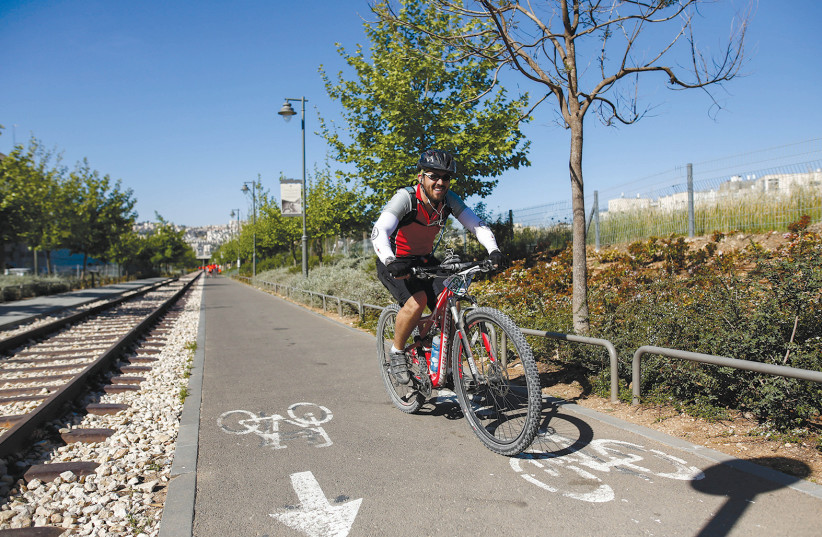
The Kerem Tunnel
This is Israel’s first bicycle tunnel and is considered by the municipality as one of the most important projects in the capital. The Kerem Tunnel is 2.1 km. long and is part of the Jerusalem Circumference Trail, a one-of-a-kind 42-km. cycling trail that encircles the capital and combines the historic Old City and modern Jerusalem in one ride.
The Kerem Tunnel connects the path between Nahal Refaim and Emek Motza. The southern entrance to the tunnel is on Refaim Park, below Ein Laban; the northern entrance is located in Nahal Ein Kerem, about half a kilometer from the Kerem intersection.
In addition to being part of the cycle path around Jerusalem and the rail park, the Kerem Tunnel also allows access to unique recreation sites, such as the Ein Kerem neighborhood, the Biblical Zoo and Aquarium, and the historic natural springs Ein Lavan and Ein Haniyeh.
New public transportation route on Yirimyahu axis
This route runs along the length of Yirimyahu Street, from the intersection of Hatzvi Street to the intersection of Shamgar Street. It includes a parallel public transportation route and a private transportation lane in each direction. This is part of Jerusalem’s new public transportation system in the north of the city, which includes the green line of the light rail, which is expected to connect to the interchange route.
In addition, the Yirimyahu Interchange joins the new public transportation routes throughout Jerusalem, including the Begin Road route, the City Entrance Interchange and the Sderot Shazar Interchange.
It gives significant priority to public transportation on a main traffic route in the city, providing those who use public transportation with a continuous journey between the entrance to Jerusalem from the west and the northern neighborhoods in both directions. It also provides quick and efficient access to parts of the city and its center, while shortening travel times and reducing traffic jams.
A designated path for public transportation will be paved on the streets of Shefa Haim, Ohel Yehoshua, and Shamgar, which is part of the Ramat Shlomo line. The purpose of the route is to enable a complementary bus service that will connect the neighborhoods in the area and add public transportation services that will connect to the green light rail line that will pass nearby.
Also, the route will support the bus service during the works on the green line to which the active lines in the area have been diverted. The path is paved from the intersection of Shamgar and Yirmiyahu streets, through Shamgar, Ohel Yehoshua and Shefa Haim streets.
Golda Meir Expressway
A new 2.5 km public transportation route was established on Sderot Golda Meir from north to south. The works at the intersection also included upgrading intersections and the traffic light systems, renewing and adding signage and traffic lights, as well as preparing infrastructure for enforcement cameras along the axis.
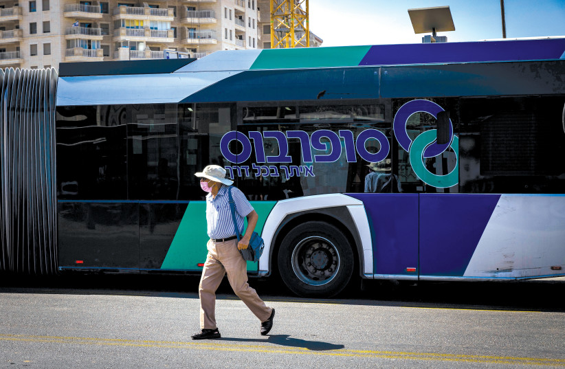
New bus lines have been added, the existing lines have been streamlined, along with two new operators of city bus lines – Superbus and Extra. Officially, the operating hours were extended and the frequency increased. However, residents who use these lines claim that this is not yet the case.
Pat Intersection
The level separation at the Pat Intersection was carried out as part of the work for the construction of the green line of the light rail that will pass over it. Vehicles will pass underground for a kilometer between Begin Road and the city center without traffic lights for about half a kilometer. A 60 m. covered passage connects Golomb and Herzog streets.
STILL WANT to use a private car in the city? The municipality is providing solutions. The new Bezalel parking lot was built at a cost of NIS 60 million, which contains 230 parking spaces. It connects to the Safra Square parking lot through underground tunnels on level five, and connects to the exits of the old parking lot. Another exit portal from the parking lot connects to IDF Square and Shivtei Yisrael street.
Electric car users will be happy to learn that with the completion of Phase I, there will be charging stations in Jerusalem. As part of the project, about 100 charging stations are being deployed throughout the city, and about 300 more sockets will be installed in the near future.
As for the coming years, most of the municipality’s projects call for the extension of the existing light rail, as well as additional new lines.
Projects expected to be completed during 2023-2024:
Extension of the red line of the light rail
The red line is the backbone of the city’s new transportation system and will be combined with a new city bus system. In the near future, the infrastructure works for the extension of the existing red line will be completed, with the last two sections extending to Hadassah-University Medical Center, Ein Kerem (in the south) and to Neveh Ya’acov in the north – about 22 km.
The infrastructure preparation works have been completed in Neveh Ya’acov, Kiryat Yovel (Henrietta Szold), Moshav Ora (near the Hadassah intersection) and Hadassah Ein Kerem.
In addition, work began on the line in the section between Mount Herzl and Hadassah Ein Kerem, and in the section between Pisgat Ze’ev and Neveh Ya’acov. The extended line is expected to be operational by the end of June 2023.
Sderot Shazar tunnels
As part of the entrance to the city, two parallel tunnels of 450 m. each, located 30 m. below the ground, are being built in one of the main entrances of the capital, Shazar Boulevard. It would allow fast and convenient movement from the entrance to the city, manage traffic at street level, and give priority to the green light rail line.
In the coming years, the urban landscape in Jerusalem will see elevators, conveyors and escalators. These will be integrated into the public areas to bridge the topographic gaps and allow more passengers to easily, quickly and safely reach the light rail, thereby encouraging the use of public transportation.
Expected to open in 2024 are the following: an escalator on Shahal Street in Givat Mordechai; elevators on the slopes of Gilo, on Golda Meir Boulevard and in Beit Safafa; and a pedestrian tunnel in Shaare Zedek to provide access between the light rail stations and the hospital.
Regarding the plans for the Talpiot area, a comprehensive transportation section will be built in order to support the expected increase in traffic in the area. Connecting the light rail to the intercity rail lines will make Talpiot more accessible.
In accordance with government plans, the municipal investment to establish a mass transit system in the city, as part of the Master Plan for Public Transportation, prioritizes the use of public transportation and links to mass transit systems, encourages non-motorized traffic and reduces the use of private vehicles. Three lines/extensions of the light rail are planned within the scope of the program and in the areas bordering it.
There are plans to extend the high-speed inter-city train line to the Khan Theater. It currently ends at the Yitzhak Navon station at the entrance to Jerusalem, opposite the Central Bus Station. According to the plan, the track will pass through an underground tunnel and include two new passenger stations: a station in the city center, near the intersection of Jaffa and King George streets, and another station in the Khan complex, near the historic train station.
Extending the train route will ease congestion at the Yitzhak Navon station, as well as allow pedestrian access to employment and commercial centers, along with creating connectivity to the light rail lines (the blue and red lines) and the planned cable car to the Old City.
According to officials at Safra Square, in the coming months the entire plan is expected to be approved, and its implementation will begin immediately. It is estimated that by 2030, the high-speed train will operate on its renewed route.
Construction of the eastern ring road (“the American Highway”; expected completion by 2024) – the largest infrastructure project since the unification of the city – includes the construction of a central longitudinal road connecting the neighborhoods in the east of the city from north to south. The project is about 10 km. long; two of the main sections of the road were recently opened.
The American Highway will allow passengers from Binyamin and Ma’ale Adumim to avoid congestion in the city, will be an alternative to using Hebron Road, and will allow quick access to the Talpiot and Malha areas. Several interchanges will be established along the road. It will pass through Armon Hanatziv and reach Ramat Rachel.
In addition, the Asher Viner Mizrach road will be paved, which will be a connection between the American Highway and Ramat Rachel and the Talpiot industrial area.
As for the east side of the city – a level separation in Kalandia (expected completion 2024) will be carried out in the northeast of the city in Kalandia for the benefit of the residents of Givat Ze’ev, residents of east Jerusalem, and residents of Judea and Samaria making their way to the capital.
The Kalandia checkpoint interchange will ease the heavy traffic congestion between Jerusalem and Judea and Samaria, since it is the main traffic artery between Jerusalem and the Binyamin area. The volume of traffic there has increased significantly over the past few years.
Light rail lines
The various lines are well into the planning and execution phases. Construction work on the green and blue lines is progressing, while the planning and approval of the yellow and brown lines are also advancing.
The green line: The green line is the second light rail route to be established in Jerusalem. It will extend from Gilo in the south of the city to French Hill in the north, with extensions to Malha and Givat Shaul. The route will connect many central points in the city and is expected to create easy and fast access to public institutions, employment centers and more.
Most of the infrastructure work of the green line, which will span a total of 20 km. of tracks, is in the execution stages, and some have been completed. With the completion of the green line, a network of five light rail lines will be operated, with the JNET network spanning 42 km. of track and 77 stations.
The blue line: The blue route will extend for 31 km. with 52 stations – from Gilo in the south to Ramat Eshkol and Ramot in the north. It will have two branches: in the north, from Geula to Ramat Eshkol; in the south, from the Khan station to Malha.
The blue route also includes the purple corridor – a horizontal line that will connect Hadassah Ein Kerem and Kiryat Hasport in Malha to Gonenim and the Talpiot industrial area, with an option to extend it to East Talpiot. During 2028, the southern section of the line, from Gilo to the city center and from Malha to the city center, will be activated. According to the plan, its full operation is expected to begin in 2030.
The yellow line: This will be a 6.5 km. route, with 12 stops along the line. It will connect the museum road and the government center via Rupin Street to the entrance to the city. It will pass along the existing red line in the city center and end in the Old City. This line is in the early planning stage.
The brown line: This line will extend for 16 km., from the Kalandia checkpoint to Umm Lison via the existing red line in Shuafat and the urban Road 1. It is currently in the early planning stage.
THE FIVE-year plan for the improvement of the infrastructure of east Jerusalem includes 43 projects to improve transportation, traffic congestion in the area, safety for passengers and pedestrians, and the frequency and quality of public transportation there. As we reach the renewal of another five-year plan, about 30 projects have already been completed.
Included are plans for the construction of new roads, including: El Esmai-Shoefat Street, to connect Moshe Dayan Boulevard and Route 60; Al Salahin Street-Ras Al Amud, where another section is planned to be completed as part of the northern ring road – 15 B in the Ras Al Amud neighborhood; the Northern Ring Road-Issawiya, where the completion of the Northern Ring Road is planned; Route 17-Tzur Bahar, where the construction of a new road connecting the two parts of the Tzur Bahar neighborhood is planned; and Al Tun-al Mahajar-Umm Tuba, where the construction of a new road is planned, connecting Umm Tuba and Road 398.
Have a safe journey. ❖