
In the small, nondescript building in central Tel Aviv sits one of the IDF’s most classified Military Intelligence units. It’s so bland compared to its surroundings that even those who live next door have no idea what the soldiers who go in and out of its gate every day do.
But while it might be boring on the outside, it is anything but dull inside.
The base, which has been in operation since the British Mandate, is home to the Terrain Analysis, Accurate Mapping, Visual Collection and Interpretation Agency in Military Intelligence’s Unit 9900.
The unit serves a critical role for the military by shaping its intelligence map. While its operations are usually kept confidential, the Magazine was granted a rare look into some of the operations carried out by soldiers in this unit.
Collecting data using signal intelligence (SIGINT), visual intelligence (VISINT), human intelligence (HUMINT), geographical intelligence (GEOINT), and more, the IDF has mountains of raw data that must be combed through in order to find the key pieces necessary to carry out a strike.

Unit 9900 is responsible for gathering visual intelligence, including geographical data from satellites and aircraft, as well as mapping and interpreting the visual intelligence (VISINT) for troops on the battlefield and decision-makers.
All troops in the unit, of which 51% are women, have backgrounds in engineering, math, physics, or other technological fields.
This elite unit serves as the military’s personal geospatial agency, responsible for making all maps that the IDF uses in Israel and behind enemy lines, such as in Gaza or Lebanon, Syria, and further afield.
The unit is also responsible for detailed maps of dense urban areas, like in the Gaza Strip where Hamas and Palestinian Islamic Jihad terrorists embed themselves in civilian neighborhoods, as well as the mapping of buildings and other potential targets.
If in previous wars troops could visualize the enemy in one clear location, today’s enemy is decentralized and much harder to visualize. They have become time-sensitive targets that challenge the IDF to strike them immediately after they are detected, before they disappear once again.
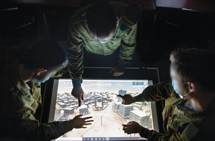
One way the IDF has begun to deal with this challenge is intelligence-oriented warfare that provides troops in the field with accurate intelligence based on advanced 3D mapping capabilities developed by Unit 9900.
The 3D maps put together by the unit allow troops on the ground, as well as fighter pilots, to get the full picture of enemy territory even before they head into the battlefield.
Troops likely to be deployed to the densely populated neighborhood of Shuja’iyya in the Gaza Strip, for example, are able to know in real-time where they might be targeted by a terrorist. Troops who enter enemy buildings are also given a clear picture of how that target looks on the inside, and can digitally go floor-by-floor, room by room to find their target before actually entering.
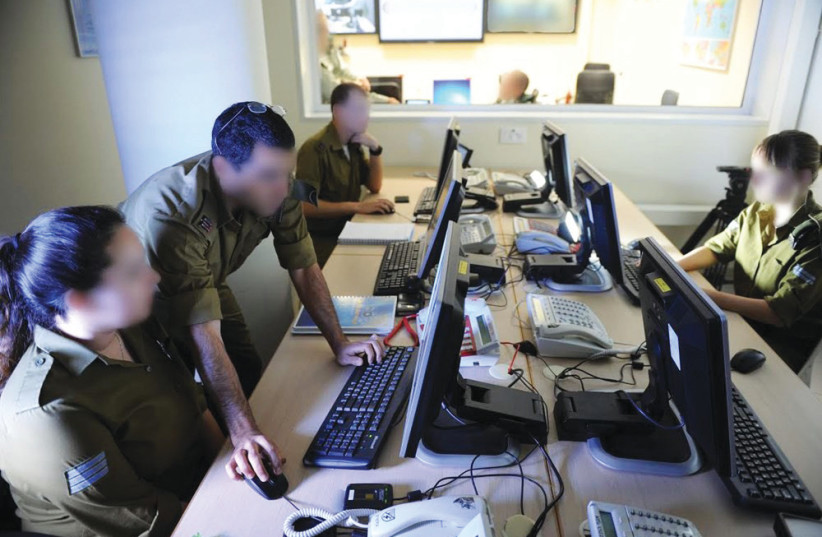
Once behind enemy lines, troops can see all intelligence gathered on their tablet in real-time. And while all the data is automated, and provides a live intelligence picture, it is the officer on the ground who makes the targeting decisions.
“Technology today is totally different. We bring mapping to applications that troops can open on their military tablets in order to see where they are, what is dangerous, and what can target them from where,” said Lt.-Col. F, the unit’s commander. “We give them the full picture, not just tell them that there’s a building but what it’s made from and how exactly it looks.”
But it’s not only the soldier on the ground who benefits from the technology. A pilot aiming for a specific Hamas operative knows exactly which window to aim his missile at, thereby minimizing civilian casualties from the intelligence provided by troops in the unit.
“At the end of the day, we all see the world in different ways,” said F. “But what the soldier or pilot sees is from us. From topography to inside homes, we were the ones who do the mapping.”
THE UNIT was instrumental during May’s Operation Guardian of the Walls. While F would not comment whether the unit took part in mapping Hamas’ Metro tunnel network, or if it helped to map the al-Jalaa tower that housed media offices before it was struck, he did concede that troops in his unit provided nonstop intelligence to the military during the fighting.
“Everything that the IDF does, it’s done with mapping. The military cannot operate without our work,” he said.
Israel conducted more than 1,500 air and artillery strikes aimed at Palestinian militant groups within Gaza. The IDF and other monitors have estimated that 151-192 civilians were killed in Israeli airstrikes during the fighting, in addition to 90-100 Palestinian militants.
“During the fighting in May, we had to make sure that what Gaza looked like was up-to-date,” F said, explaining that after every strike they had to map the area in order to show what the location looked like. “It had to be done really fast and in a precise manner.”
The timing and precision weren’t just paramount following strikes, but prior to them as well, especially in urban areas full of civilian institutions like schools, hospitals and mosques.
“Urban areas are more complicated, it takes a lot of GEOINT, sensors, and the right technology to connect the dots to give the full picture,” F said, explaining that troops use Artificial Intelligence to extract buildings from images in order to best understand the scale and make-up of the building or other targets.
F added that by doing so, they can give troops and pilots intelligence that shows what the building exactly looks like – its height, where the windows are, and its surroundings. This enables the pilots to choose the right munitions and where exactly to send the munition.
The unit’s satellites, which have gathered mountains of GEOINT over the years, were able to automatically detect changes in terrain in real-time so that during the operation, the military was able to detect launching positions and hit them after firing.
For example, troops from Unit 9900 using satellite imagery were able to detect 14 rocket launchers that were located next to a school.
It was also the unit’s troops that provided the intelligence that allowed the Israeli Air Force to target the bedroom of former Palestinian Islamic Jihad leader in Gaza, Baha Abu al-Ata, killing him and his wife in 2019.
While Hamas is the ruling party in the Gaza Strip, the head of Palestinian Islamic Jihad’s (PIJ) Al-Quds Brigades in Gaza, Abu al-Ata was considered the man calling the shots in the blockaded coastal enclave.
Although PIJ is a Sunni Jihadist movement, it is fully supported by Iran, which directs the group through the group’s chief, Ziad Nahala, who sits in Damascus.
As the second-largest group in the Gaza Strip after Hamas, PIJ under al-Ata’s command had been assessed by military intelligence as a factor increasing the risk of an escalation in the blockaded coastal enclave, since it is not under the direct control of Hamas and acts independently for its own interests.
Al-Ata was considered as an institution in himself and was involved in planning attacks against Israel, manufacturing arms and long-range rocket launching capabilities. He had survived several assassination attempts by Israel, including during Operation Pillar of Defense in 2012, and in 2014 when his home was struck.
Despite constantly switching homes, his luck ran out four years ago when a missile fired by an IAF jet, whose pilot had been provided with exact intelligence on where he was sleeping, fired a missile into his bedroom.
“We were the ones who mapped the home of Baha Abu al-Ata,” F told the Magazine as we sat in his office. “It took only a few hours.”
Following the targeted assassination, the group fired over 400 rockets and mortars toward southern and central Israel in less than 50 hours. But the military still considers the targeted assassination a success, one that removed one of Gaza’s most problematic leaders.
IT’S NOT just threats close to Israel’s borders that keep the troops of this elite unit busy. They are part and parcel of Israel’s war-between-wars campaign (known in Hebrew as MABAM).
With Israel concerned by Iran’s growing hostility in the region, troops from the unit have been keeping a close eye on the Islamic Republic with its army of satellites, the latest one – Israel Aerospace Industries’ Ofek 16 – having been launched last July.
Like other reconnaissance satellites launched by Israel since its satellite program began in 1988, Ofek 16 will be used to monitor threats facing Israel. The Ofek 16 carries Elbit’s electro-optic, high-resolution camera which can photograph 15 sq.km. with each shot at a resolution of 50 cm. from an altitude of 600 km.
Israel is one of only 13 countries with satellite launching capabilities, and like Israel’s Air Force, the satellite industry is a key component of the Jewish state’s strategic military capabilities. They are the real eye-in-the-sky, keeping a close eye on Israel’s enemies 24/7 from afar.
Although the exact number of Israeli satellites in orbit remains classified, they are reported to number in the double-digits. When it comes to their use, the unit is responsible for all satellites.
And while most satellites have a lifetime of several operational years before they go out of service, satellites built by IAI, like the Ofek 5 launched in 2002, continue to operate far longer than the design specifications said it would.
The satellites, such as Ofek 16, transmit images including over locations in Syria where Iranian forces are known to operate. These images are only part of the tools used by the unit to help the Israeli military carry out surgical strikes against targets belonging to Iran and its proxies.
Israel’s war-between-war campaign has been going for close to 10 years with alleged Israeli strikes taking place in Syria, and according to foreign reports in Iraq and other countries. The past year has seen an increase in the number of operations allegedly carried out by Israel targeting Iranian rockets, missiles, air defense systems, unmanned aerial vehicles, weapons production infrastructure, weapons storehouses, and more.
A December report released by Airwars, which tracks all civilian harm by foreign actors in Syria since 2014, between 14-40 civilians have been killed by airstrikes blamed on Israel, making the rates of civilian casualties in strikes by the IAF by far the lowest compared to other foreign actors in the war-torn country.
According to Airwars researchers, they were unable to identify a single civilian harm claim against Israeli actions in the first four years of the campaign, dubbed by the IDF as “Operation Chess.” Meanwhile, over 600 militants and Syrian and Iranian troops have been killed in the strikes since 2013.
“There is no MABAM without precision mapping,” F said. “We do everything so the strikes will be precise, so that the civilian casualties will be low. It’s something we always think about.”
Part of IDF chief of staff Aviv Kohavi’s multiyear plan was the digital transformation, a process that would make the IDF an advanced network-centered, multi-dimensional war machine that would keep Israel way ahead of its adversaries. But Israel’s military also knows that it needs to use all available resources to feed that machine, including from the civilian market.
“The military has advanced a lot in the past three years. There has been a new multiyear plan, new needs in the military and new changes” F said, adding nonetheless that the unit is always looking at what there is in the civilian market.
“The rate at which we work is very high and we use a lot of technology. And with the technology, we are able to transmit intelligence to ground forces, and that is revolutionary.”