
Israeli coastal cities are known to have been significant strategic stops for maritime trade. Various regimes controlled these port cities at different times in history, and from excavations it has become clear that wars were waged over these ancient port cities, leading us the understand that they held great geopolitical advantages for competing empires.
Situated all over the country, more than 200 dirt hills covering ancient civilizations have been excavated over the years. Three of them – Megiddo, Hatzor and Beersheba – have even been recognized as official UNESCO world heritage sites. Below, you will find descriptions of four national parks that are located along the Mediterranean coast that combine historical visits with enjoyable walking paths along the coastline.
<br>1. Ashkelon National Park
This national park is one of the most interesting sites along Israel’s Mediterranean coast. Its ruins are nestled deep in the sandy dunes that loom over Ashkelon’s beaches, dating back almost 4,000 years ago. One of the items found in excavations of the ancient city is a massive 15 meter-high earthen rampart with a glacis that was used for defense purposes, with an impressive, vaulted gate at the entrance.
Although at present, most equate Ashkelon with rockets raining in from the Gaza Strip, in ancient times the city was a bustling market town with great strategic and geopolitical significance, and was an important center for maritime trade.
The best place to begin your tour of the national park is the Canaanite Gate, which dates back to 1850 BCE. Once you pass through the gate, walk up the path that leads up to the top of the site, from which you will have a phenomenal view of the Mediterranean Sea, the northern part of Ashkelon, the earthen rampart and the fortification wall. From there, you continue walking until you reach the center of the park.
When you’ve finished walking around the site, you can take the path that leads down to the beach. Beware that swimming in this area of the sea is strictly forbidden, due to the strong undertow and unstable water conditions. Once you’re down on the sand, you can look up at the sandstone kurkar ridge that forms the edge of the ancient structure. You will also see granite pillars that are sticking out of the ancient walls parallel to the ground. It is unknown for what purpose this structure was built.
Directions: At Ashkelon junction, turn west toward the sea. Drive along Ben-Gurion Boulevard until you reach a T-intersection. Then, turn left and enter Ashkelon National Park.
<br>2. Tel Dor National Park
Located near the beaches of modern-day Dor and Nahsholim, Tel Dor National Park is one of the country’s most gorgeous nature reserves. This impressive site sits on a sandstone kurkar ridge in the southern Carmel coastal region. Amateur and professional photographers alike have always been attracted to this stretch of beach, and there are remains on the site that date back to the Bronze Age and to the Roman Empire.
In excavations of the site, archeologists found remains of a bustling city.
There is an extremely popular trail up above the cliff that runs parallel to the coastline. The first stop along the path is a picturesque bay with small pools where you’ll find lots of colorful fish swimming around. In the past, there were industrial fishponds here.
Continue on the path, and you will reach the next stop, which are remains of an ancient Roman temple. These remnants date back to the reign of Alexander III of Macedon, a.k.a. Alexander the Great, at the height of Hellenistic civilization.
Later on down the path, at the edge of the cliff, you will have a clear view of the ruins of the ancient port, the beautiful blue lagoon of Nachsholim, and the blue sea stretching all the way to the horizon. Once you’ve had enough time enjoying the view, you can return back to your car the same way you came.
Directions: From Road 4, turn west onto Road 7011 toward Kibbutz Nachsholim. Pass the entrance to the kibbutz and continue north on a dirt road toward the Nachsholim Cemetery. Follow signs for Tel Dor National Park.
<br>3. Palmahim Beach National Park
Spread out over 22 hectares, Palmahim Beach National Park officially became a national park 20 years ago. There is a 600-meter path that winds its way through the park, which culminates at the steep cliff at the ruins of Yavne-Yam, an ancient port city that dates back to the Middle Canaanite Period. It is surrounded by a large fortress that protected the city from attackers from the sea, and ruins were excavated on site that date back to the First Temple and Crusader periods.
Continue in a northerly direction along the path, which climbs up the ridge of the mountain. As you ascend, the view of the surroundings and the sea will get better and better. If you are a flora enthusiast, then you will want to pay close attention to the unique surroundings on top of the ridge, which includes sea fennel and evening primroses.
At this point, you can either walk back to your car the same way you came, or you can descend to the beach and walk back along the water. If you’ve chosen the latter, you will be able to see the fortress located at the northern tip of the park.
Directions: Drive on Road 4, then at Gan Raveh junction, turn west onto Road 4311 toward Palmahim. You will pass over Nahal Sorek, the Paratroopers Forest and the entrance of the kibbutz and then finally you will reach the beach parking area.
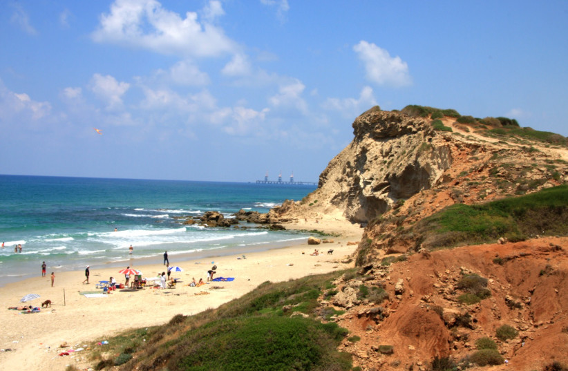
<br>4.Gedor National Park and Nature Reserve
Located between Givat Olga and Michmoret, you will find Gedor National Park and Nature Reserve. Most people have enjoyed splashing around in the clear water at Gedor Nature Reserve, but not many people know about the archaeological site that was uncovered nearby just 30 meters above the beach. Archaeologists have uncovered clay shards that date back to the Bronze Age and the Middle Ages on the eastern and northern sides of the hill. At the top of the hill, a structure was uncovered that is believed to have been a guard tower.
The walking path begins at the Givat Olga parking area. From there, set off toward the south on the path that is parallel to the shoreline. You will notice a number of paths, but it doesn’t really matter which one you choose, since they all lead to the same spot at the top of the ridge. As you walk up, you can stop anytime you want to look out at the gorgeous view of the beach and the little bays at the foot of the ridge.
After you’ve walked about a kilometer, you will notice an old building that the British Mandate forces used as a shooting range. Just past this structure, you will reach the apex of the hill. Be on alert, since there is a real danger here of falling off the edge of the cliff. If you continue a little farther south, you will reach a quaint hidden bay. Now, it’s time to turn back and return the same way you came.
Directions: At Yanai junction, turn toward Michmoret. Pass by the entrance to Michmoret and drive north another 300 meters until you reach the Givat Olga parking area. ■
Translated by Hannah Hochner.