
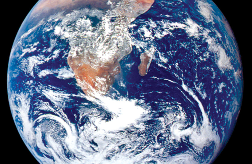
What can be done to predict Northern California wildfires, loss of vegetation in the Amazon rainforest or combat periods of intense drought in Israel? These are just some of the questions that the VENµS probe hopes to answer. Despite its name, the probe’s goal was solely to orbit the Earth’s atmosphere, and take picturesque photographs of land masses and oceans, providing scientists with new ways to understand our environment and better protect it. The nanosatellite was launched in 2017 after a collaboration between the Israeli Space Agency and its French counterpart, CNES. It has been orbiting our blue planet for close to three and a half years, and will continue to do so for the next two at least.
From facilities in Toulouse, France to Israel’s Elbit Systems Ltd, Rafael Advanced Defense Systems, Israel Aerospace Industries, and the Jacob Blaustein Institute for Desert Research at Ben-Gurion University of the Negev; many teams worked tirelessly on the plan. The Jerusalem Report spoke to Prof. Arnon Karnieli, who headed the research at BGU, and devotes his time to studying the environment and improving agricultural efficacy in the Negev, which is no easy feat.
Karnieli has been passionate about the state of our environment for several years, dating back to his time spent at the University of Arizona, where he focused on watershed management, or soil and water conservation that aims to reduce floods and sediment control as well as increasing agricultural food production. “By addressing the problems of land and water use by humans, we can create a more sustainable environment,” he said. Currently, he investigates the desert environment of the southern Negev and attempts to uncover clues to improve vegetation, and predict weather climates to assist farmers in producing better crop yield through precision agriculture. The benefits of using such technologies are abundant, among them the ability to identify possible environmental stressors and reduce them, producing a better-quality crop that is financially efficient and sustainable.
The VENµS probe was launched from a CNES base in French Guiana on August 1, 2017. Of its many objectives, it aims to help researchers better monitor the influence of humans on soil, topography, and climate. The idea behind the nanosatellite began back in 1987 when Israeli and German groups proposed a project, coined David, to develop a multispectral space camera with a unique set of lenses, mirror-blockers, and detectors. The resulting endeavor, which came to fruition in 2005, was named “Vegetation and Environmental New Micro Spacecraft,” or VENµS, and was based upon the original designs.
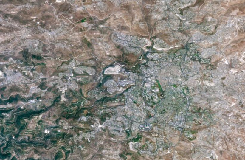
The probe continues to conduct routine flybys of the Earth, and attains high resolution, multispectral images of specific sites around the world. “VENµS’s scientific objective is to acquire data that deals with monitoring, analyzing, and modeling land surface functions that are under the influence of environmental factors and human activities,” Karnieli explained. The nanosatellite is equipped with a large number of narrow spectral bands, which help the sensors onboard measure specific wavelengths on the electromagnetic spectrum. The narrower the band is, the easier it is to produce images at an increasingly sharper resolution. “The probe is able to revisit the same location within the span of two days and has the ability to observe targets on the Earth at the same time of day and at the same viewing angle.” Finally, all the data can simply be downloaded and accessed by researchers on Earth in no more than two days.
“Nowadays, there are satellites with better spatial, spectral, and temporal resolution, however, there is no current space system with a combination of all three,” Karnieli noted. In layman’s terms, images produced today can be obtained from different angles, radiations, and elevations. Yet the VENµS probe gives researchers starkly accurate data when viewing the Earth at the same angle. “This feature is essential when observing small objects, for example, when looking at a vineyard, since the reflected radiation is influenced by the directions of the vine rows and the interaction between the plants and the soil’s background,” he continued. All this data is more efficient at predicting weather forecasts and environmental changes for a unique spot.
So far, VENµS has captured images of agricultural fields in various areas of the world. The satellite enables farmers to see changes in crops not only on the scale of an entire field, but rather across numerous small plots. In turn, this helps farmers conserve their resources and stop using excess water, fertilizers, and pesticides. And the innovative sense doesn’t stop there. Use of these images allows scientists to monitor changes in forests and nature reserves. Recording the fluctuation in bodies of water can help them focus on the quality of rivers and coastal water bodies by tracking amounts of chlorophyll associated with algae blooms, and turbidity caused by floods and land erosion, as well as various pollutants. “Atmospherically speaking, some parts of VENµS were designed to gather information on aerosols such as dust, smoke, volcanic ash, human-caused air pollution, and water vapor,” he added.
One of the system’s most impressive features allows scientists to acquire information on day-to-day changes in crops’ growing cycles to identify environmental stressors caused by water shortages, insects, or heat waves – which can be tracked within a short time, making it essential in an emergency response.
The study can also assist experts in combating climate change. “Our globe is changing,” Karnieli reiterated. While those changes include global warming, the world population is also increasing. “This is leading to an explosion in global food demand, pressure exerted on land masses, the energy crisis, environmental degradation, threats to biodiversity, and more.” Researchers are looking for a way to address all these issues, which are fundamentally challenging our understanding of this planet.
While the VENµS probe’s use is too short for this goal, it can assist by providing a baseline for such studies with its heavily-detailed data. By using its recordings of moisture in the air released by fuel, scientists can probe how that may have an influence on stronger wildfires. The probe’s data can also study the regeneration and mortality of trees in contested areas, like the Amazon rainforest and in the Mediterranean, predicting worsening events. All this adds to the nanosatellite’s distinctive appeal, since revisiting a certain area and photographing it numerous times in high detail, can lead to improved models of environmental sustainability. “This can pave the way for scientists and policymakers to enhance environmental policies and protections,” he said.
From the Sde Boker Campus of Ben-Gurion University nestled in the vast and dry Negev desert, researchers process the images received from the satellite at the VENµS Scientific Center. The information is later stored, archived, and catalogued as teams pour over numerous images and use them to improve agriculture, grazing, forestry, and water quality in the region. Currently, VENµS transmits images to both the Israeli center and the French one in Toulouse. Under this agreement, Israel is responsible for the images of its homeland, while France is responsible for all other images of Europe, the Amazon, and the US. “I hope that in the coming year, pandemic restrictions will lessen and we can compare our models and data in person,” he added.
Currently, Karnieli is analyzing how routine biological life cycles are influenced by climate factors and habitat. “We obtain seasonal changes and characteristics of crops such as wheat, barley, and potatoes, in five farms in the northwestern Negev, working to increase their sustainability and output.” By training computers to recognize and model the crop’s unique characteristics, farmers, managers, and suppliers can see real-time information on multiple crops across a broader scale.
“There are several issues with obtaining water in the Negev. We train computers to recognize these models and then predict a future event and protect against it. In the desert, we rely mainly on ground water. We’re trying to use this technology to further conserve water,” he noted.
Aside from the technical aspect, Karnieli believes that people can work every day toward protecting the planet through education, which he believes is crucial to pass on the message: our planet is wondrous yet fragile.