
Nasa’s Curiosity Mars rover captured a "postcard" picture of the Marker Brand Valley, thanks to a new update that it received in April, according to a press release on June 13.
The photos, which were originally taken in black and white, by the Curiosity’s navigation cameras had color added later on Earth.
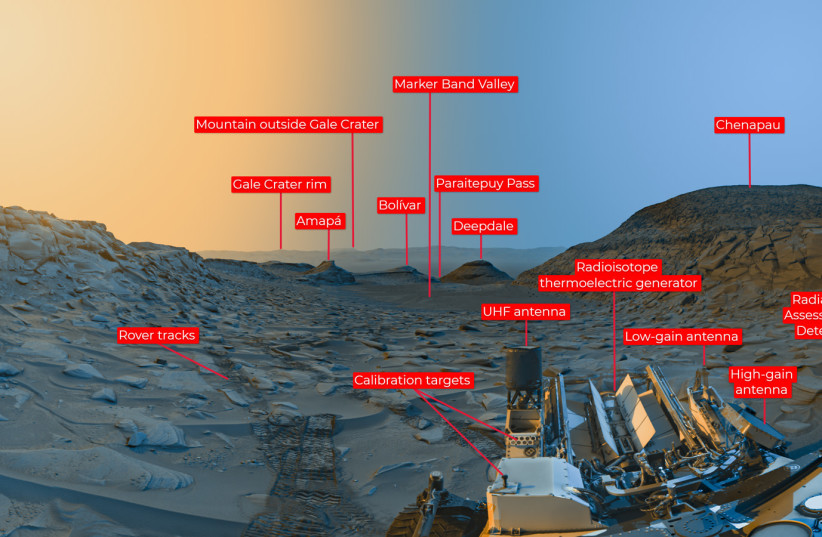
The photos had been taken on April 8 at 9:20 a.m. and 3:40 p.m. local Mars time. Having been taken at different times of the day, the different lighting created a picturesque scene. Blue was added to the photos taken in the morning, and yellow to those taken in the afternoon. The photos were then edited together on Earth.
"Anyone who's been to a national park knows the scene looks different in the morning than it does in the afternoon," said Doug Ellison, a Curiosity engineer.
"Capturing two times of day provides dark shadows because the lighting is coming in from the left and the right, like you might have on a stage—but instead of stage lights, we're relying on the sun."
"Mars' shadows get sharper and deeper when there's low dust and softer when there's lots of dust," Ellison added.
The rover, which has been exploring Mars since 2012, took a similar picture in November 2021.
What do the images show?
The image shows the foothills of Mount Sharp in the valley, which have a height of 3 miles. The clear weather also allowed for another mountain to be seen in the distance, this one 54 miles away.
The postcard shows the rover’s three antennas and nuclear-power source.
The Marker Band Valley is also known as “sulfate-bearing region.” The rover has found evidence that there had once been a lake there.
Deeper into the valley, the rover has found two hills which were named “Boliver” and “Deepdale,” between which lies the "Paraitepuy Pass."