
A few weeks ago, an Arab friend from east Jerusalem asked me to meet her for coffee downtown. I asked if she preferred Aroma or the Coffee Bean on Jaffa Road. But she clarified, “No, let’s meet in our downtown!”
That’s when I realized, and not really for the first time, that the same word can have entirely different meanings to people living in the same city.
The classic western Jerusalem “downtown” is a triangle, formed by Jaffa Road, Ben-Yehuda Street and King George Street. It is full of restaurants, coffee shops, hotels and an abundance of stores.
For our eastern Jerusalem neighbors, “downtown” consists of three streets as well: Az-Zahra, Sultan Suleiman and Salah a-Din. But while they don’t form a triangle, the streets are connected. And, like western Jerusalem’s downtown, they feature restaurants, cafes, hotels and a variety of shops. However, the eastern Jerusalem downtown boasts, in addition, historical sites that date back hundreds, and even thousands, of years.
Unfortunately, travel articles and guidebooks – including my own – generally ignore this lively, historic area. All they offer are selected well-known sites on Nablus Road, a couple on Suleiman Street, and the rest inside the Old City. That is about to change.
The untold lively, historic downtown of eastern Jerusalem
Suleiman Street is the main drag running between eastern and western Jerusalem. It was constructed by the Turkish Ottoman rulers of Jerusalem in the late 19th century, after Muslims began moving outside the Old City walls. It became the center of Arab commerce.
In 1917, the Jerusalem authorities surrendered to British General Edmund Allenby at a ceremony just outside of Jaffa Gate. Three years later, the British inaugurated Allenby Square between City Hall and the Old City walls with a three-meter-high war memorial. Commerce continued to flourish along Suleiman Street.
After the holy city was divided into Israeli Jerusalem and Jordanian Jerusalem in 1948, much of Suleiman Street was transformed into a no-man’s land sporting refuse, barbed wire and land mines. The commercial center then moved east, in the direction of Flower Gate and the junction of Suleiman with Salah a-Din streets.
Once Jerusalem was reunited during the 1967 Six Day War, Allenby Square became IDF Square. But what to do about the street named for Suleiman? After all, Suleiman did repair the Old City walls in the late 1530s, and deserved to have his name in lights. In the end, two names were bestowed upon this main road: Paratroopers’ Brigade begins at City Hall and runs east to Damascus Gate, where Suleiman Street takes over.
ACROSS FROM Damascus Gate, the first building on Suleiman Street is a gorgeous edifice that was probably once a wealthy effendi’s villa and today houses at least one dentist’s office. The next structure on the street is a stunning, immense white building constructed as a Catholic guesthouse, called Paulus-Haus (St. Paul’s Hospice).
A few months before its grand opening, founder Father P. Wilhelm Schmidt, was hit by a tram. He had just celebrated his golden jubilee – 50 years in the priesthood – and was taking a long-deserved vacation in his native Germany when the accident occurred. The almost-completed guesthouse, one of his pet projects, was finished without him in 1886.
The eye-catching new guesthouse rapidly became the center of German Catholic activities in the holy city and today houses the German Association for the Holy Land. It also operates the Schmidt School for girls, with about 500 Christian and Muslim pupils.
From the promenade next to the Old City walls, there is a wonderful view of its rooftop, whose serrated railing echoes the Old City ramparts. Shelters with beautiful stone arches and columns stand in two of its corners.
On the sidewalks below the dentists’ building and Schmidt School are dozens of street hawkers, bazaar-like stands and shops. Here you can find everything from socks, toys and telephones, to the Jerusalem baygele, an elongated roll sold with the Middle Eastern za’atar herb.
Under the nine arches of the next enormous building, Arab Bank (sic), are even more shops. Founded in 1930 as the first private financial institution in the Middle East, today Arab Bank serves clients in its more than 600 branches throughout the world. The colossal structure next door is home to a government clinic and an Israeli bank. A large supermarket operates beneath its beautiful stone arches.
Behind the supermarket and Arab Bank, on top of a hill, walls encircle the As-Sahira/Az-Zahra Cemetery. It was probably first used in the 12th century to hold Saladin’s fallen soldiers, after the battle in 1187 when Sultan Salah al-Din (Saladin) Yusuf ibn Ayyub took the city from the ruling Crusaders. A week later, he offered prayers at the Aqsa Mosque on the Temple Mount.
When established, the cemetery was called As-Sahira, the night walkers. This may refer to guards who stayed up all night to defend Jerusalem. Today most people call it Az-Zahra (flower) instead of As-Sahira.
Ramadan is a month-long religious holiday of fasting, prayer and self-reflection and Muslims refrain from eating from dawn to dusk. Since the 19th century, at least, a cannon at the edge of the cemetery has been fired to signal the end of the daily fast.
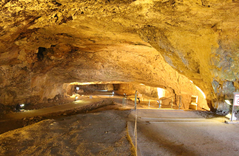
Zedekiah’s Cave, on Suleiman Street along the Old City walls, is really an enormous ancient limestone quarry. The largest man-made cave in Israel, it is 20,000 sq.m. and runs the length of five city blocks under the Muslim Quarter. Suleiman sealed it off in 1540, soon after the walls of the city were restored, perhaps because of security considerations. It was discovered in the early 1850s, when a Protestant minister visiting Jerusalem was taking a walk outside the walls and his dog fell into a deep pit that was actually part of the cave.
Many believe that it was this quarry that provided the stones for Solomon’s Temple, and it almost certainly was used by King Herod when building the Second Temple. Stones from the quarry also contributed to a clock tower built by the Ottoman Turks in 1907, which no longer exists.
According to legend, the barely trickling spring inside the cave is made up of the tears shed by King Zedekiah, the 20th and last king of Judea, as the Babylonians captured Jerusalem and destroyed the Temple in 586 BCE. Zedekiah may have fled through the cave in order to escape the Babylonians; however, according to the Bible, he was caught on the Jericho plains. His captors killed Zedekiah’s sons right in front of him, then gauged out his eyes, and led him in chains to Babylonia.
Zedekiah’s Cave is currently closed, but hopefully will reopen in a few months with a new and exciting audio-visual program.
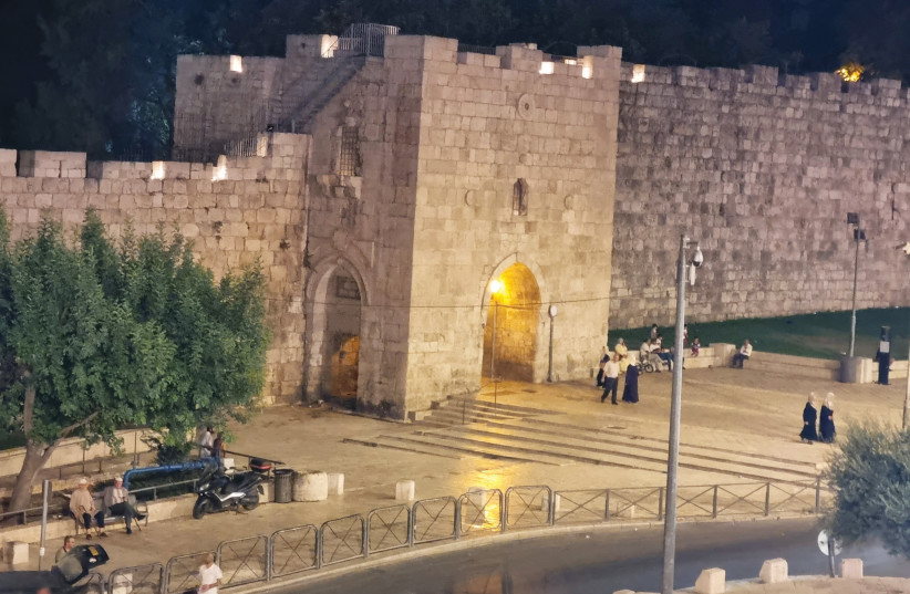
FURTHER EAST along the walls, a modest gate leads into the Muslim Quarter of the Old City. When it was built in 1539, as one of the last gates added to the walls at the time, the entrance was from the east (around the corner from the modern gate). This meant that you couldn’t walk straight into the quarter, but rather had to turn left in order to make it difficult for an enemy to rush in.
The modern entrance, on the northern side, was opened in 1875, so it would be easy for people living in neighborhoods outside the Old City to come and go. Although sealed off in the 19th century, it is open today (when not blocked by crates and other overflows from the merchants).
Non-Arabic speakers often call this “Herod’s Gate,” because of the apparently erroneous belief that King Herod had a palace nearby. To everyone else, it is known as Flower Gate (Bab Az-Zahra). While one reason given for the name is the flower motif on the gate, there are actually similar flower decorations on many of the others. It is more likely that the name refers to the nearby Az-Zahra Cemetery.
Directly across from the gate, Salah a-Din Street is always clogged with cars and brimming with people. On the corner stands the police station and post office, built, according to one source, over a municipal slaughterhouse in the early 1960s.
Just behind it is a Suleiman Street newcomer called Cocktail Taibaat (“good tasting cocktails”). Located on the rooftop, with an amazing view of the Old City walls and the street below, Cocktail offers fresh fruit cocktails and fresh fruit hookahs to diners from all walks of life. Beautifully lit at night, Cocktail also features crepes, smoothies, coffees and cakes. Note: You have to climb a lot of steps to get to the rooftop restaurant.
Salah-a-Din Street is a colorful commercial byway, featuring bookstores, pharmacies, hotels and shops. It also hosts the District Court of Jerusalem, and the American School of Oriental Research, founded in 1900 and later renamed for its most famous director, William F. Albright. The very first American archaeological research establishment in the Middle East, it supports several dozen archaeological excavations in Israel.
Salah-a-Din Street runs into Az Zahra, wonderfully diversified, with shops, unusual cafes and historic hotels. The enormous, rounded structure on one corner is the National Hotel, built in the 1940s and the first of its kind to appear in eastern Jerusalem. Its new coffee shop on the ground floor offers a terrific view of the goings-on along the street.
Among the cultural centers on the street are the Royal Conservatory of Music, lodged in a building more than a hundred years old; the Palestinian Art Court, emphasizing visual arts, is located on the second floor of a traditional 1930s house.
Yabous, established in 1985, is a very active center for performing arts. On the building’s ground floor, the newly opened Wasat Albalad (middle of the city) Café replaced the popular Nordic Café a month ago and is already welcoming diners. Nearby is the beautiful Turkish consulate.
The very oriental Az-Zahra Hotel dates back to 1900, when it was one of the first buildings to be erected in the area and was called the Az-Zahra Palace. In the early 1930s, it was home to the British High Commissioner Sir John Robert Chancellor for a time.
Az-Zahra Street ends in Rockefeller Park, found behind the splendid Rockefeller Museum – the very last building on Suleiman Street.
A SAD thought: On a repeat visit to the street this week, I ran into a group of giggly schoolgirls. They asked me to take their picture, and were absolutely astounded when I spoke to them in Arabic. The girls asked me repeatedly if I was Jewish – and thought it was extremely strange that a Jewish woman knew “their” language!
Aviva Bar-Am is the author of seven English-language guides to Israel. Shmuel Bar-Am is a licensed tour guide who provides private, customized tours in Israel for individuals, families and small groups. See www.israeltravels.com for more information.