
Bats are helping Israeli zoologists and geographers to determine where the warmest air exists in cities. Using a new research approach called “biologically-assisted sampling” in which pigeons can map air pollution in cities and rats can help monitor pollution in sewage systems, scientists from Tel Aviv University (TAU) used the flying mammals to study Urban Heat Islands in the Dan region. The researchers said: “We must use any mobile platform that can assist us.”
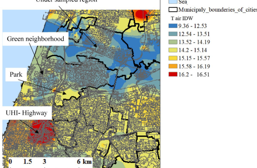
Urban Heat Islands have much warmer temperatures in metropolitan areas than the non-urban spaces surrounding them. In a creative collaborative effort between its zoologists and geographers, the university study found that during the winter months, the air over the Ayalon Highway can be up to five degrees Celsius warmer than the air in Yarkon Park.
The interdisciplinary study was led by Prof. Yossi Yovel and Dr. Aya Goldshtein of the Bat Lab for Neuro-Ecology in the School of Zoology, the Sagol School of Neuroscience, and the Steinhardt Museum of Natural History, in collaboration with Prof. Alexandra Chudnovsky, Prof. Oded Potchter, and the late architect Dr. Limor Shashua-Bar of the Porter School of Environmental Studies.
Utilizing the unique capabilities of bats for research of Urban Heat Islands
The study was published in the journal Applied Geography under the title “Bat bio-assisted sampling (BAS) for monitoring urban heat island.”
Chudnovsky explained that “Urban Heat Islands are a well-known urban phenomenon. These are dense urban areas that are several degrees warmer than their surroundings, but for objective and environmental reasons, it can be difficult to measure them. Placing stationary measuring stations on every street is nearly impossible, and deploying people with mobile sensors is expensive. Furthermore, measuring stations only capture ground-level temperatures and don’t provide a 3D temperature analysis. One potential solution is using drones, but permits to fly drones in urban areas and flight time limitations (after 20 minutes they need to land and recharge) pose challenges.”
In the current study, the research team decided to leverage the unique capabilities of bats, known for their exceptional navigation skills and familiarity with urban environments. “Bats are more adept pilots than drones,” said Yovel. “They can fly 100 kilometers in one night, and they are active exactly when the heat island phenomenon is at its peak – at nighttime.”
For the experiment, the researchers attached tiny heat sensors to Egyptian fruit bats from an urban bat colony and released them in downtown Tel Aviv. The clever bats easily found their way back home, and on the way, they mapped air temperatures over different areas including the city center, the Ayalon Highway, Yarkon Park, and Herzliya.
With the bats' help, the first 3D map of Urban Heat Islands in Gush Dan was created
The experiment, which was conducted in the winter between 8:00 PM and 2:00 AM, revealed temperature differences of two to five degrees Celsius between dense urban areas and city parks. The researchers compared the data transmitted by the bats to readings from four meteorological stations in Tel Aviv. Simultaneously, the researchers conducted a large-scale field experiment using mobile meteorological stations to verify the data. They also equipped staffers with similar devices and sent them to different parts of the city to collect comparable measurements.
“On the one hand, these are very light temperature sensors, weighing just 0.2 grams, so they are not as accurate as a heavy meteorological station. But their advantage lies in their providing a comprehensive climatic picture in a short timeframe,” said Chudnovsky. “An analysis of the measurements revealed significantly higher temperatures in the Ayalon area compared to Yarkon Park, where temperatures dropped. As the bats crossed Yarkon Park towards Herzliya, temperatures rose again. Thanks to the bats, we were able to create the first three-dimensional map of Urban Heat Islands in Gush Dan.”
“There’s a lot of talk about smart cities and the ‘Internet of Things,’ but there are many animals already roaming the city, and we can attach tiny sensors to them without affecting their behavior,” Yovel concluded. “For example, when monitoring pollution in sewage systems, rather than using expensive and complex machinery, we can rely on the rats that are already present there.”
The Environment and Climate Change portal is produced in cooperation with the Goldman Sonnenfeldt School of Sustainability and Climate Change at Ben-Gurion University of the Negev. The Jerusalem Post maintains all editorial decisions related to the content.